


Tropical Weather
Galveston is no stranger to tropical weather. During hurricane season, from June 1st through November 30th, Galvestonians keep a close eye on the Gulf, and to trusted weather sources. This is also the height of the tourism season for the island. We’ve compiled tropical weather data below to help you plan your travels.

Weekend Adventure Pass
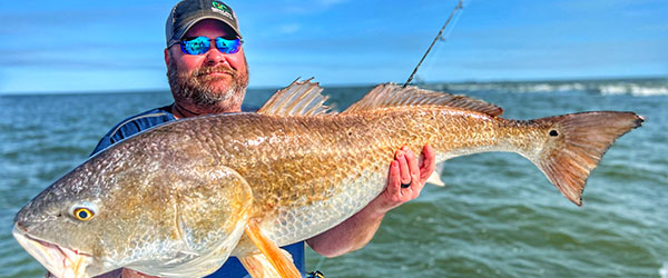
Experience a Fishing Adventure!
National Hurricane Center Tropical Weather Discussion
Tropical Weather Discussion NWS National Hurricane Center Miami FL 0005 UTC Mon May 20 2024
Tropical Weather Discussion for North America, Central America Gulf of Mexico, Caribbean Sea, northern sections of South America, and Atlantic Ocean to the African coast from the Equator to 31N. The following information is based on satellite imagery, weather observations, radar and meteorological analysis.
Based on 1800 UTC surface analysis and satellite imagery through 2230 UTC.
...MONSOON TROUGH/ITCZ...
The monsoon trough passes through the coast of Guinea near 09N13W to 05N20W. The ITCZ extends from 05N20W to 04N37W to 02N49W. Scattered moderate to isolated strong convection is noted from 01N to 09N between 10W and 25W.
...GULF OF MEXICO...
A digging mid to upper level trough is moving across the eastern Gulf. This is supporting a frontal boundary which extends from the Ft. Myers, Florida coast near 27N82W to the western Gulf near 22N96W. Scattered moderate to isolated strong convection is noted in the central Gulf along and south of the boundary from 22N to 27N between 84W to 91W. This convection is producing frequent lightning and likely gusty winds and locally rough seas. Exercise caution.
Gentle to moderate winds are noted north of the frontal boundary with light to gentle winds south of the boundary. Seas are slight to moderate across the basin. Dense haze is also occurring in the western and central Gulf from agricultural fires in Mexico, including the Bay of Campeche.
For the forecast, the frontal boundary and associated weather will continue to shift E to SE across the eastern Gulf, reaching the vicinity of the Florida Keys Mon night and the Straits of Florida Tue. Winds are likely to be gusty along with rough seas in and near the shower and thunderstorm activity. Meanwhile, hazy conditions due to agricultural fires in Mexico continue across most of the western Gulf and Bay of Campeche. Moderate to locally fresh SE return flow will develop again across the W Gulf Tue through Fri night.
...CARIBBEAN SEA...
Surface ridging extends across the basin anchored by high pressure northeast of the Caribbean. This is supporting widespread fresh to strong E to NE winds in the south-central basin, including the Gulf of Venezuela. Seas are 6 to 8 ft in this area. Additionally, fresh to locally strong winds are occurring north of Hispaniola and the Gulf of Honduras. Elsewhere, gentle to moderate trade winds prevail. Seas 3 to 5 ft are noted across the rest of the basin. Isolated thunderstorms are noted in the SW basin off the Colombia coast, with most of the convective activity happening in the Pacific.
Dense haze caused from agricultural fires in Mexico is noted across portions of the NW Caribbean, northward from the northern coast of Honduras to southern Quintana Roo, including the Gulf of Honduras.
For the forecast, winds in the Gulf of Honduras will diminish to fresh speeds Mon morning. The fresh to strong E winds in the south-central Caribbean will shift eastward to offshore of NW Venezuela through Tue night and diminish early on Wed. A rather vigorous deep layer trough will dig southward across the western Caribbean Mon night through Fri, and support very active weather over the central portions E of 80W Tue through Fri, perhaps a little longer. This feature is likely to induce a surface trough in the central Caribbean. Fresh to strong E to SE winds will develop in the central Caribbean Tue and shift eastward through Thu while diminishing to mostly fresh speeds, but remain gusty. Smoke due to agricultural fires in Central America continues across the Gulf of Honduras, but appears to be thinning out some.
...ATLANTIC OCEAN...
A frontal boundary extends from 31N73W to the West Palm Beach, Florida coast. Numerous moderate to strong convection is noted off the SW N Atlantic, including across the east coast of Florida, N of 25N and W of 68W. Frequently lightning can be expected with these storms in addition to gusty winds and locally rough seas. Gentle to moderate winds and moderate seas are noted across this area outside of the strong thunderstorms.
In the central Atlantic, surface ridging extends over the area anchored by a 1023 mb high pressure near 35N28W. A trough extends from 31N54W to 26N66W. Scattered moderate convection is noted ahead of this trough from 26N to 31N between 47W and 52W. Moderate winds are also noted east of the trough. A second trough is analyzed from 31N41W to 26N42W. Light to gentle winds prevail N of 20N with moderate E winds S of 20N. Seas of 4 to 6 ft are noted across the central Atlantic.
In the eastern Atlantic, the 1023 mb high pressure is also influencing this area. Moderate to fresh N winds are noted across the Africa coast to 30W. W of 30W, gentle to moderate winds prevail. Seas are to 4 ft.
For the forecast W of 55W, the weak front off the coast of Florida will slowly continue southward through Tue. Scattered to numerous showers and thunderstorms along and near the trough will shift south with the trough affecting the waters east of florida to the Bahamas and south of about 28N. Behind this feature, a new front will sink southward into the waters offshore of Georgia and NE Florida early Mon, and move southeastward and stall from near 31N72W to SE Florida late Tue. A trough will develop southeast of the weakening front and extend into the central Bahamas early on Wed, and drift eastward through Fri night. Low pressure is expected to form along the trough near 24N68W Thu evening and move NE through Fri night.
AReinhar

Take a Self-guided Tour
Experience a Fishing Adventure!


See Sharks Overhead
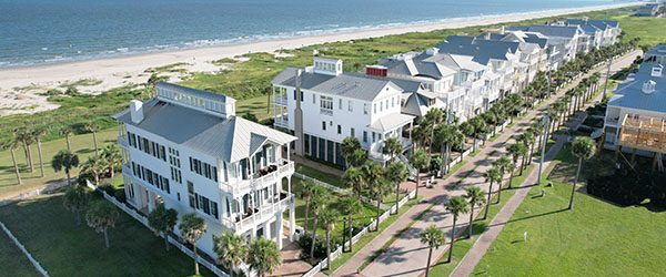
Luxury Vacation Rentals Available
It’s Not TV. It’s


Request a Free Visitor Guide
If you’d like to receive a visitor guide or request additional tourism information, please click here.